Keno City- Explore the Nature, Mines, Wild and Keno
Keno City, yes not Keno game but a city of this name is a great place to visit when in Canada. It has a small community in Yukon at the end of the Silver Trail highway. With not much of population you will enjoy this peaceful place which looks like some old and traditional urban as well as rural area. You can reach Yukon and then drive 13 kilometers away from Elsa.
Historically Keno City was the site of a former silver lead mining area proximal to Keno Hill and it is owned by Alexco Resource Corp who currently own and operate the various silver lead and zinc deposits in the Keno Hill area. It was once as famous as Dawson City for mining and was the second largest silver producer in North America. Mining still takes place today, and many of the network of hiking trails cross the historic mine sites, there is also a mining museum charting the history of mining in the area.
Actually rich silver and lead ore deposits were found on Keno Hill in 1919, and since then the population of the community has fluctuated in response to the mining activity in the area. When in 1989 United Keno Hill closed the mines, literally overnight, the people in the Keno area who decided to stay chose a more sustainable economy and that is tourism.
This small village exudes history and character as do many of the inhabitants of this fascinating settlement. This Keno City is inhabited by quiet and tranquil community but who gave this city the name Keno. Well if you guessed right then it was named after the popular played game Keno which was favourite in mining camps at the turn of the 20th century.
What can you enjoy and visit at Keno City
Keno Mining and Museum, Keno Hill, Signpost Road, Butterfly trail, Silver Basin Gulch Monument trail, Lightning Creek trail, Gambler Gulch trail, Keno 700 trail and Mount Hinton trail besides many more.
The Keno Hill
 Keno Hill
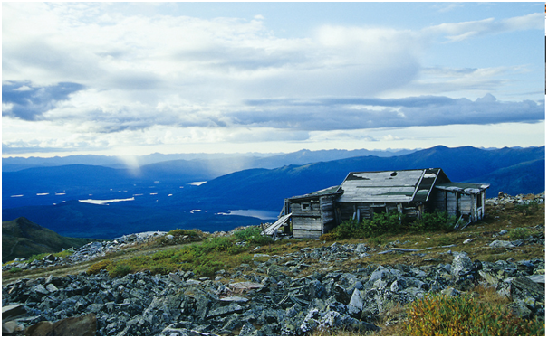
You can drive to the top of Keno Hill to see the famous signpost and magnificent views. Among the mountains Keno Hill has many tracks and trails which are no longer used for mining, where experienced hikers, mountain bikers and winter sports enthusiasts come to enjoy. At the height of . 1,848 m the top of Keno Hill stayed above the glaciers in the last ice age. Descendants of plants and insects including butterflies that were here during the ice ages remain in the meadows.
You can visit this Keno hill in late spring or early summer and take advantage of the long hours of sunlight to hike late into the evening.
Enjoy the melody of the birds singing after the sun disappears. While on the trails you will encounter old buildings and artifacts. Stop-do not take the artifacts as it is against the law. They are part of Keno’s mining heritage and should be left for the enjoyment of others.
The Silver Trail Highway
 Silver Trail Highway
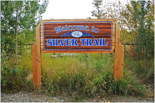
The Silver Trail highway is 112 km from Stewart Crossing to Keno City at the base of Keno Hill. Highway 11, called the Silver Trail, is within Nacho Nyak Dun First Nation traditional territory, an area with sensational scenery, hiking, fishing, berry picking and camping.
The Silver Trail starts at the north end of the Klondike Highway bridge over the Stewart River. This hard- surfaced road to Mayo has many glimpses of the Stewart River, several pullouts and views of glaciated terrain. The Village of Mayo, at kilometre 50, has propane and gas, motels, restaurants, a post office, liquor store, grocery store, recycling station, swimming pool, nursing station, RCMP, airport and float plane services. The Binet House Interpretive Centre contains a collection of historic photos, interpretive information, a three-dimensional map of the region, and an extensive geology and mining display. Beyond Mayo, there are no gas stations or food stores. Make sure that you have all the supplies you will need.
Mount Haldane
 Mount Haldane
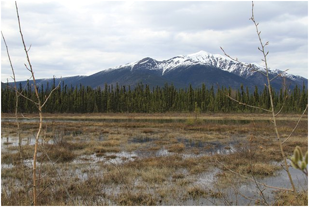
Mount Haldane, rising 1,200 metres to 1,839 metres, is an impressive peak. To hike on the hill, take the access road on the left, just before the inn at the lake. Follow this gravel road for 2 km to a parking lot. The trail goes in three zigs up the east side of the mountain to the ridge saddle south of the main peak. It is 7.5 km, following a track to the ridge crest, then 1 km along the rocky, exposed crest to the summit. There are picnic tables with good views that serve as objectives for shorter hikes.
About 5 km past Elsa, the Hanson Lake trail branches off to the north and is a rough, narrow road with several steep grades, best suited for pick-up trucks or four-wheel drive vehicles. Haldane Lake is visible to the west, about 9 km away. A cut-line provides easy access to the south shore. The lake is periodically stocked with rainbow trout.
A number of unmarked tracks along the highway access secluded lakes and streams. You can paddle to McQuesten Lake or the head of the Beaver River which joins the Stewart River. Outfitters and wilderness guides take horses into the back-country of the Wind, Snake and Bonnett Plume drainages. This area is commonly used by snowmobile and dogsled expeditions.
Duncan Creek and Mining Museum
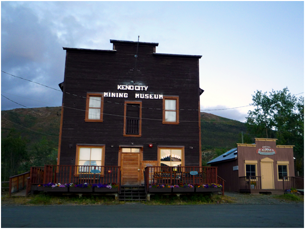 Keno City Mining Museum
The Duncan Creek Road is an alternate route back to Mayo from Keno City. Check at the museum in Keno City to get conditions for this gravel road. In the early days of mining, silver ore was hauled over it by horse and wagon. Along this road, about 4.5 km from Keno City, you can take a short hiking trail, with a stream crossing, to get a good view of the Duncan Creek canyon, site of the original Gustaveson gold strike. A short distance before the turn-off to Mayo Lake is a family placer mine, Duncan Creek GoldDusters. It has scheduled tours and gold panning. At the Mayo Lake junction, turn left for fishing, boating and berry picking. There’s a good view of the dam across the outlet of Mayo Lake. The dam creates a reservoir for the hydro plant downstream. The Duncan Creek Road ends back at the Silver Trail. Mayo Landing was the staging ground for silver ore being shipped out by a fleet of river stern wheelers.
Sign Post Road
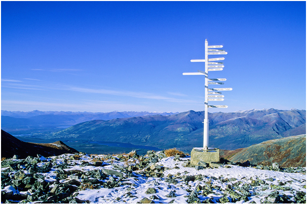 Sign Post Road
A drive to the famous signpost at the top of Keno Hill will reward you with a breathtaking panorama. You rise quite rapidly past changing views over the valleys. By kilometre seven, the road levels out and you are above tree line, passing alpine meadows overlooking the McQuesten Valley and the Ogilvie and Wernecke mountains. This 10.5-km gravel road is not recommended for large motorhomes or trailer rigs. There are switchbacks and no pullouts although there is turnaround room on top. Inquire at the museum for road conditions. At the top, overlooking Faro Gulch, sits the signpost. United Keno Hill Mines erected the original wooden signpost (right) in 1956, when the company hosted a group of visiting scientists during International Geophysical Year. Arrows point to the cities represented by delegates. The current steel signpost dates from 1989. There’s a good chance you will see marmots in this area to be observant.
Visitor services in Keno City include lodging in cabins and the Keno City Hotel, dining at the hotel and snack shop. Washers, dryers and showers are available for public use at the recreation hall. Camping at Keno Campground, in town next to Lightning Creek.
If Keno city is named after Keno then certainly there are casinos in and around where you can enjoy Keno and other casino games.
The casino is called Diamond Tooth Gertie’s Gambling Casino is in Dawson City, Yukon Territory, located at 4th Avenue and Queen Street, Y0B 1G0, Canada. You can contact the casino at phone: (867) 993-5525, (867) 993-5575. This casino is open Fri-Sat 7 pm-1 am. The casino’s 8,000 square foot gaming space features sixty-four gaming machines and twelve table and poker games. Also the casino has one restaurant where you can enjoy great meals.